Mount Shasta area: 10-14 September
Participants: Elisabeth Zinser (leader), Gabriele Bennett, Barb Settles, Nancy Skinner
Camp: Siskiyou Lake “Resort” Campground
Hiking: Siskiyou Lake, McCloud Falls, Castle and Heart Lakes
[photos coming soon]
On the Camp: For months we had been booked for a campsite at Jedediah Smith State Park, aiming for trails in the Redwoods and along the coast. Northern California fires brought frequent smoke into that region and Hwy.199 was closed for an extended period. I cancelled that reservation and booked a campsite at Lake Siskiyou when air quality was following a much favorable air quality pattern going into September. Having participated in a BIG adventure there under Tysen’s leadership a ½ dozen years ago. The ‘resort’ offers cabins (most very basic), an area for crowds of RVs, and many clusters of campgrounds.
The location was wonderful for the hiking opportunities and air quality, but less optimal for the condition of the Lake Siskiyou campground. While our campsite was ample for four tents, many sites were in disrepair (huge potholes even in our campsite drive) and former campers had left trash (especially beer and pop cans) strewn around in campsites and bushes. We disposed of many. It was obvious that the “resort” made no effort to clean campsites between campers. The restroom was cleaned daily, but needed maintenance. Access to showers was nearly ½ mile distant from our site. The only staff we saw was the occasional security guard cruising around a time or two each day. There were a few campsites in use nearby on our first day or two, but no one in sight by the time we departed. Apparently, very little use after Labor Day weekend.
In short, the Lake Siskiyou Camp ‘Resort’ charged higher rates than the conditions and amenities provided: $40/night base senior rate, added $20 for the second car, added $5/night for each of two additional campers. Perhaps pricing and conditions account for low usage, although the website had shown many “unavailable” sites. This is a private enterprise. It made me appreciate the customary conditions and pricing schedules of our state and national campgrounds, supported in part by our tax dollars and managed by competent state and federal employees.
On Hikes: We hiked each of our 3 full days.
Days One and Five (9/10 and 9/14): Mostly driving, camp set up/take down, eating.
Day Two (9/11): Hiking the trail around Lake Siskiyou for an 8-mile RT journey from our campsite plus a swim for three, and a 6.4-mile out and back for me. We were at about 3,200’ in this area. Our ascents and descents were under 800’. Very enjoyable hiking with great views. Of course, we recognized this anniversary of our nation’s/world’s tragedy on “9/11” twenty-two years ago.
Day Three (9/12): After a leisurely breakfast together, we packed up to drive to nearby Castle Lake. Horrors: One car would not start, no matter what we tried. The initial assumption was a ‘break freeze’ due to a tire up against the side of the huge pothole on our drive. Gabriele came to the rescue and called AAA on her membership. The assumption was that the car would need to be towed back to Medford and Nancy would depart early with AAA. A nearby camper tried jumper cables to jumpstart the motor. No luck. So, we bolted into action to prepare the other car for 3 of us to remain and return together, while Nancy took down her tent and packed her car. We stuck together as good campmates do, spending time in camp playing Barb’s fun game (Farkle) and/or reading. By late afternoon, AAA arrived with a big flatbed ready for towing. Then a ‘miracle’ – the gentleman had a very powerful motor to jumpstart the car successfully. The battery had taken a siesta because the inside overhead lights were left on for two days, and possibly also having had car doors open too long while accessing supplies and food. WORD OF EXPERIENCED ADVICE: It can be easy to inadvertently bump the switch to hold the inside dome light on (versus the position that has it go on when a door is opened and off within 30 seconds after the door is closed). Avoid leaving doors and trunk/hatch open for long periods of time when parking for extended periods.
Given the scenario we had come to expect, we were thrilled that Nancy could stay and the car was fine. So, the tent went back up while contents in cars were rearranged. Our next step was to take a drive somewhere to further charge up the car battery.
Nancy insisted that we save the day by driving to a hike somewhere. Barb came up with the solution: A drive to hike on the McCloud River Trail to view the McCloud Falls (lower, middle, and upper). Note: The ‘landmark’ to locate this trail is the Fowler Campsite located south of Mt. Shasta on I-5 (before Dunsmuir), taking Exit 736 onto Hwy. 89 (toward McCloud, Burney Falls, Lassen National Park), traveling past the town of McCloud to a right turnoff for Fowler Camp. Large parking lot located at the TH at Lower Falls.
Once at the TH parking, we took off to follow Barb’s guide to hike along the McCloud River in the lovely hues of late afternoon. Right away is the Lower Falls—a relatively short drop in a beautiful view up the river. Next we came to the Middle Falls—the most expansive flow of water coming down into river pools, quite inviting for several youth who were jumping off rocks and frolicking in the river. A special highlight was seeing the bright flowering Indian Rhubarb (see picture). At this point, the trail continues up a grade with switchbacks to a view down over the Upper Falls. The hike was less than 4 miles RT with an elevation gain under 250’. It was a perfect way to salvage the day.
One last glitch for the day: The return drive was confusing due to unclear ‘diversions’ to access I-5 because of extensive highway repairs (or perhaps my inability to follow the “diversion’ signs). In short, we meandered across to the other side of the freeway onto a narrow dirt back road in the woods, and then down into the residential area and finally Mt. Shasta Resort and Lake Siskiyou. Thanks to iPhone navigation and map, we made it.
By the time we arrived at camp, it was a dark for a challenging but fun experience cooking and enjoying dinner while wearing our headlamps and having the ‘candle light’ ambiance of a sun-powered night light on the table.
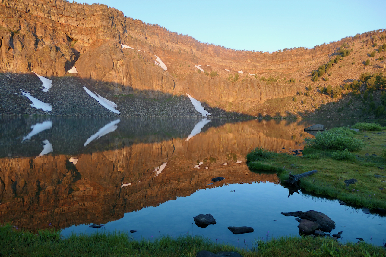
Day Four (9/13): A hike (climb actually) from Castle Lake to Heart Lake RT. Castle Lake access road is about ½ mile from camp and climbs a zig-zag grade for 7 miles up to the parking and toilets at Castle Lake. We arrived early and beat the usual ‘crowds’ (though minimal after Labor Day). We were nearly the first on the trail up to Heart Lake.
The rocky trail climbs just 1.3 miles but with a 600’ elevation gain to Heart Lake (a small lake in the shape of a heart). The views and forest flora along this journey are magnificent. Our three fast hikers continued on the trail past Heart Lake in search of an extended climb to yet higher terrain. I climbed up a knoll through the bushes to a favorite access point above Heart Lake that overlooks Castle Lake and the most expansive views north, east, and south. Mt. Shasta and lower intervening mountains were crystal clear.
Anticipating that my fellow hikers would be hiking for a long while, I enjoyed a beautiful meditative hour atop that knoll gazing over the landscape and Castle Lake below. Before descending, I walked around at Heart Lake, seeing it full of more water this time of year than I’ve witnessed on earlier hikes here (after morning kayaking on Castle Lake).
It was fun to encounter other hikers and dogs by this time of day. Several did not know to climb the bushy knoll above Heart Lake, so were thrilled to make that diversion for the views. A highlight was conversing with two women from Brazil who come to this region often to hike and enjoy terrain much different than in their country. From them I discovered that my fellow hikers had already passed by, descending back to Castle Lake. The Brazilians had met up with them. Ouch! I was unaware that they had encountered a trail closure early on their ascent above Heart Lake. So, I returned down the rocky trail as quickly as possible. They were enjoying quiet time on the shore, but eager to try the trail around the other side of Castle Lake in search of a good swimming spot. That we did together over rocky and tree-rooted tangles amongst magnificent trees and beside the crystal-clear lake sporting reflections of the cliffs on the other side. I knew some lake access spots from kayaking to them in the past. We found them for a refreshing swim.
On Camp-time and Meals:
We were such a compatible bunch. Our time in camp was full of good conversations, shared dinners, quiet time reading, and playing Barb’s game of Farkle (actually Barb and Nancy played). We prepared our own breakfasts and lunches, but enjoyed a shared dinner scheme. Each of us took one of our four nights to cook on Nancy’ stove. We enjoyed a variety of vegetarian recipes. Clean up was a group effort, making light, speedy work of it.
In summary, this trip had a few challenges and yet turned into a wonderful shared experience full of special memories and deepening friendships.
Steens Mountain: 1-6 September
Hikers: Maria G., Mary K., Tony D., Barb S., Sherry W., Charisse S.
[photos coming soon!]
Sep 1, Fri. Mary and Charisse left Ashland at 7am. Maria, Barb and Sherry left at 8:30, stopping at Burns to pick up Tony who had been in the John Day area for a couple of days. It rained intermittently on the drive but stopped before we arrived at South Steens Campground (SSC, $8 per night per site with Senior National Park Pass) allowing us to pitch tents and eat without getting wet. SSC is at the end of a well maintained 20-mile gravel road; it has 34 sites and although it was Labor Day weekend, only about half of the sites were occupied. It’s shady, with toilets and a pump providing potable water at one end of the campground. That night there was a thunder and lightning storm in the area and it poured on us.
Sep 2, Sat. We had expected rain on Friday when we drove to SSC but the forecast before we left was for clear weather after that, so the plan was to backpack into Big Indian Gorge on Sat. Well, it was still raining when we awoke, and instead we did a day hike of a bit over 9 miles in Little Blitzen Gorge. This was nice for Mary and Barb who had been to Steens two previous times but had not gone very far into Little Blitzen. The trail is in good shape; there’s one creek crossing early on, for which water shoes might be handy. It rises gradually and isn’t difficult to follow. The rain stopped after a few hours and we hiked in 4.5 miles, a bit past a campsite that could accommodate 2 tents or squeeze in 3 small ones. That night back in camp there was another a thunder and lightning storm and it poured on us.
Sep 3, Sun. Rain continued the next morning, but we were all tired of spending time in our tents, so off we went in our rain gear to Riddle Brothers Ranch, a historic site maintained by BLM. Because people had been removing artifacts, there is now a gate on the road and volunteer caretakers, who welcomed us and explained the history of the area. It’s possible to drive to it on the gravel road that we walked, except on Mondays and Tuesdays when the gate is closed. In all, we ended up walking about 9 miles this day. We also learned from the caretaker that the Desert Meadows Trail we had considered hiking was a “hypothetical” trail, pretty much impassable as it hasn’t been maintained for a long time. Weather cleared and we hiked 1.5 miles on the Levi Brinkley Trail from the historic ranch site to the confluence of the Little Blitzen and Donner und Blitzen rivers. The name Donner und Blitzen is apt; it’s not after Santa’s reindeer, but thunder and lightning. But there wasn’t much rain Sun. night, yay!
Sep 4, Mon. (Labor Day). If we were going to backpack in Big Indian Gorge as planned, this was our last chance because we had reservations at Alvord Desert campground for Tuesday night ($25-30 per person for campsite including use of hot springs). It was cloudy but the forecast was for improving weather. What to do? Considerations included possible unforecasted rain (reports had been wrong all along); options if the one campsite were occupied (we’d seen backpackers in Little Blitzen Gorge); would there be time to hike Pike Canyon on Tuesday after backpacking out and driving to Alvord; tiredness. After much discussion, we all agreed that Mary, Barb (both of whom had backpacked twice in Big Indian Gorge and Charisse (who was excited to try out her new gear) would backpack into Big Indian Gorge and Maria, Tony and Sherry would go with them for 5 miles and day hike out. This trail too is well maintained and ascends gradually; it has three creek crossings in the first couple of miles, for which water shoes are advisable. As it turns out, there’s a campsite a bit less than 5 miles in, below a distinctive rock standing in a grassy area; a short, indistinct trail slants down to a grassy campsite by the creek. After having lunch together and setting up camp, the backpackers reached several waterfalls cascading down the gorge walls. The campsite easily accommodated their 3 tents, was shady; however, with the clear skies, it was a cold, damp night.
Sep 5, Tue. The day hikers drove the Steens Mountain Loop Road up to its closure due to rockfall and walked to overlooks of both Little Blitzen and Big Indian Gorges. The views from here are impressive. About a mile beyond the gate, three large boulders have been placed in the road, suggesting that the closure of the continuation of this road to the top of the ridge and the Wildhorse Lake trailhead may not be temporary. It would be worthwhile to check the status of this road before planning to drive up there (access to the Wildhorse Lake trailhead would still be possible via the North Steens loop road, even if this road remains closed, but the drive is quite a bit longer). Around noon, the day hikers drove about 70 miles over to Alvord to camp at Pike Creek. They had plenty of time to hike 2 miles up the Pike Creek Trail, which offers some spectacular views and rock formations. It’s drier than the trails we hiked on the west side of Steens, and a bit steeper (average about 500’ elevation gain per mile, with some up and down). The backpackers arrived at Alvord around 4pm, after a short side trip to Fields Station to enjoy their famous milkshakes. Charisse’s husband Walter arrived at 6pm, and we all drove 3 miles to soak in the hot springs until after dark. The campsite is pleasant, but does not have toilets or a water tap (the creek is right there, though); the charge of $25-$30 per person seems a bit on the high side, but it’s probably the best spot in the area. The night was clear and warm.
Sep 6, Wed. We drove home. Maria’s car started home at 7:30am and stopped at the BLM rest area between Lakeview and Bly for a picnic lunch and got home at 2:30pm. Mary and Tony headed back a bit before 9 am. They were looking forward to lunch at the Indian taco stand in Bly, but it was closed until 20 September. They returned to Ashland at about 5 pm.
Wildlife isn’t that abundant in this area. Bears don’t seem to be present, but we did see a fair amount of coyote scat (they seemed to be enjoying the several varieties of red berries that are in season). We saw some wild horses in the open areas near the road into South Steens Campground. A couple of eagles soared above us as we hiked the Pike Creek Trail. We encountered a praying mantis devouring a grasshopper and a tiny bright green frog in that area as well. Mud wasps were visible there, too, and rattlesnakes apparently inhabit the canyon. For eastern Oregon, Steens is surprisingly green, and late-season wildflowers – rabbitbrush, goldenrod, sunflowers, purple asters, and gentians – added color to our hikes.
Warner Mountains: 2-5 August 2023
Five of us – Jay Ach, Mary Cutler, Karen Grove, Bart Jenkins, and trip coordinator Tony Davis – backpacked up to Patterson Lake in the Warner Mountains, east of Alturas, CA.
Our destination was the same as the 2021 trip, but we took a different route this time, hiking there and back on the Summit Trail from its northern end at Pepperdine Campground. And unlike 2021, this year there was no looming threat of smoke.
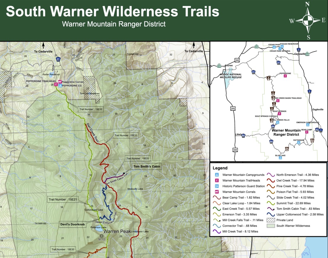
For more geological insight about the Warners, and more photos, see Karen’s Warner Range blog post.
We stuck with our planned itinerary, summarized here (though as we’ll note below, we would have liked to explore other options!):
| day | from | to | distance | time | comments |
| 1 | Ashland | Pepperdine campground | ~180 miles | ~4 hours | via Alturas |
| 2 | Pepperdine trailhead | Patterson Lake | ~6 miles | ~4.5 hours | ~2100’ elevation gain |
| 3 | Patterson Lake | Patterson Lake | ~6-8 miles | ~5-7 hours | day hikes to Devil’s Knob and southward on Summit Trail |
| 4 | Patterson Lake | Pepperdine trailhead | ~6 miles | ~2.5 hours | ~2100’ elevation loss |
| 4 | Pepperdine trailhead | Ashland | ~205 miles | ~4.5 hours | via Cedarville and Alturas |
Day 1:
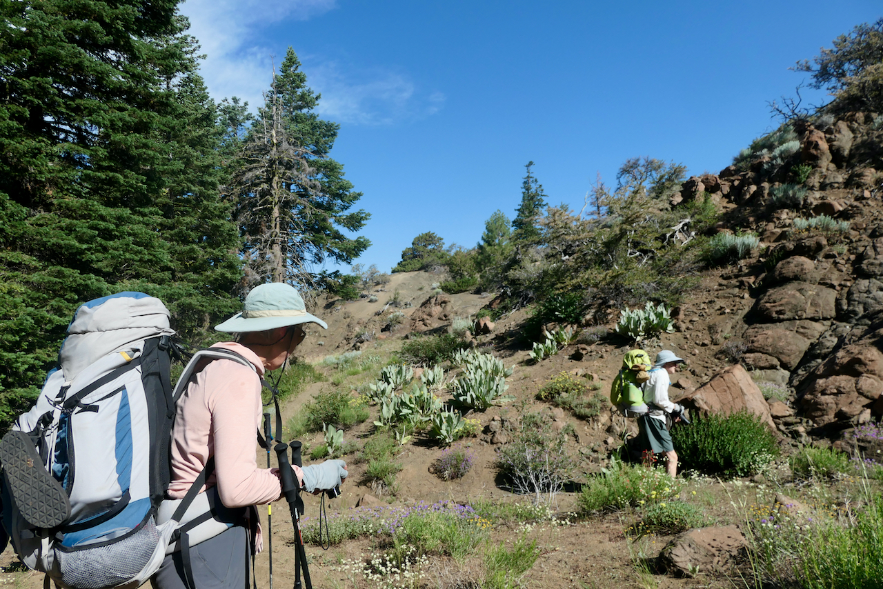
The four of us from Ashland set out in Karen and Jay’s Subaru a bit after 10 am. Bart left Yreka somewhat later on his own. The drive was smooth. The four of us reached Alturas in time for lunch. Agave Azul (known for lack of margaritas in 2021) was closed, so we chose a dilapidated taco place next to the burger spot. The food turned out to be better than the setting. We then strolled around the corner to the ranger station, where friendly but not terribly well informed staff didn’t enlighten us about trail conditions. They weren’t able to contact any of the rangers out on the trails, either. They did offer free samples of obsidian and a free permit to go gather up to five gallons (!) of the stuff at any of four sites to the north. Since we had time, we got a permit and headed about 20 miles north on 395 to the tiny community of Davis Creek, then east a few miles on a gravel road (road 11) to one of those sites. This proved to be a rubble-strewn slope with huge amounts of shiny black obsidian; we gathered some specimens and then drove back through Alturas, then east up the ridge to Pepperdine Campground, arriving around 5:45.
Pepperdine Campground is pleasant enough, with shade, picnic tables, and pit toilets. There’s no potable water, though, and for the moment, no fee to camp there. Bellowing bovines were audible, and some had left reminders of their presence in the campsites. There were a few mosquitoes but they weren’t too bothersome. Bart arrived not long after the rest of us, around 6:30. Since we’d eaten lunch in a restaurant, we ate the lunch food we’d brought, along with a bottle of wine.
Day 2:
After loading up our backpacks and reparking the cars by the trailhead, we set out on the Summit Trail around 9:15. Starting at about 6900’, the trail is a near continuous ascent up to Patterson Lake at 9000’. It passes through a mix of woodlands, meadows, and more exposed areas as you go. It was in many places surprisingly lush; abundant wildflowers and butterflies made the journey enjoyable.
It was quite evident that this year was wetter than 2021. The trail itself is well maintained, easy to follow in most places, and somewhat dusty. Note that there are no reliable sources of water on this trail until you’re quite close to Patterson Lake, so bring what you need from the trailhead.
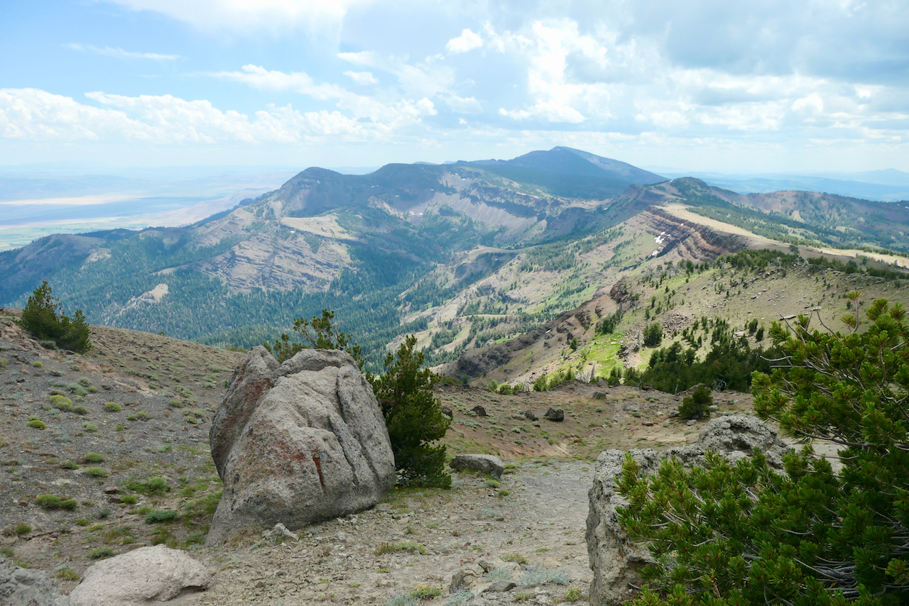
There were lots of geologically interesting features along the way; the top of the Warner Mountains consists of volcanic formations from multiple lava flows overlying older sedimentary rocks. In many places the upward tilt of the formations towards the east is obvious. Once up on the ridge, there are broad views on both sides: rugged topography off to the east descending to the Surprise Valley, and gentler slopes toward the west. A few patches of snow were visible on the mountains ahead of us.
About five miles along, we reached a small lake called Cottonwood Lake on some maps (consistency is not a strongpoint of Warner Mountains cartography). About a quarter mile above Cottonwood Lake, a trail branches off to the east from the Summit Trail. Labeled the Little Cottonwood Trail on maps, it is shown as descending to a junction with the Owl Creek Trail, which roughly parallels the Summit Trail lower on the east side of the mountains and eventually joins it not far from Pepperdine trailhead. We’d been told that the Owl Creek Trail was open, and were considering returning that way if we could reach it via the Little Cottonwood Trail. As it happened, we met a guy right at the trail junction who had just attempted this, and had turned around, finding the Little Cottonwood Trail impossible to follow (this mirrored our attempts in 2021).
From that lake, one more steep but short climb and then a bit more gradual ascent brought us to Patterson Lake by 1:45. This is a striking site with good campsites. We were beaten to the most convenient one (which we’d used in 2021) by a couple of guys from Alturas, but found another along the small creek flowing out of the lake. In the late afternoon we followed a short trail from our camp to broad view of the Surprise Valley, and explored a bit further to a dramatic outcrop where we watched a storm cell passing to the north.
The night was clear, calm, and cool, with a nearly full moon.
Day 3:
Our plan for this day was to explore the Little Cottonwood Trail, still hoping for the option of returning to Pepperdine trailhead via a different route. In any case, we would visit some of the meadows and waterfalls on the east slopes, and the hoodoos known as Devil’s Knob (note that the map above places “Devil’s Doorknob” in the wrong location; the hoodoos are actually east of Patterson Lake and well below the ridge and the Summit Trail). Starting out around 8:30, we descended the Little Cottonwood Trail, which was easy to follow initially, though overgrown in spots.


As it was getting warm, we opted to continue south first to see the hoodoos, which were easily reached by 10 am.


We poked around there for a while and then headed back to try and follow the Little Cottonwood Trail in earnest. Not much further down, our efforts met the same fate as the hiker’s from the day before; some bits and pieces of trail just seemed to peter out in the woods. Realizing that this wasn’t a viable option for returning to Pepperdine with our backpacks on, we gave up and headed back up. This whole area is very scenic, though, with meadows, colorful geology, and waterfalls, so the morning’s explorations certainly weren’t a waste.


After returning to camp, most of us set out again southward on the Summit Trail, which climbs about 400’ above Patterson Lake and then descends towards junctions with the Pine Creek Trail (which we descended in 2021) and the Mill Creek Trail (which we ascended then). Even the short climb to the saddle above Patterson Lake was worthwhile for the sweeping views of the ridge extending south.
Mary went quite a ways further, and Bart reached the Pine Creek Trail junction.
Birds are everywhere at the lake. Corvids squawk and honk incessantly, and a couple of ospreys flew so close to our camp that you could hear their wings flapping.
Clouds begin gathering that afternoon, and around 5 pm we took cover. Raindrops soon turned to hail, and the ground became white. There was a respite after a couple of hours and we emerged to eat dinner before heading to bed. Rain continued off and on until about 10.
Day 4:
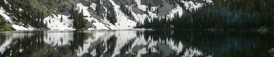
By morning it was clear and calm again. Patterson Lake is beautiful just after sunrise.
We departed just after 9, catching a whiff of smoke from an old fire that the two guys from Alturas had made earlier. They were already heading down. Our own return was quick and uneventful, taking just over 2.5 hours. On the way, we met a trail runner on his way to Patterson, and on his way back, he stopped to ask us if we’d camped at that site just above the lake. Apparently the guys hadn’t put out their fire and it had reignited that morning. Luckily the trail runner was there to put it out. A good lesson: if you smell smoke, it’s worth the trouble to check and make sure its source is really extinguished.
Back at the trailhead just before noon, we met a young ranger heading up to the lake, who related some interesting information relevant to our experience. For about ten years, there was a hiatus in trail maintenance in the South Warner Wilderness. That’s why the Little Cottonwood Trail dissolves into the woods. In the last couple of years, work on the trails has resumed, and the Owl Creek Trail has received some attention, though lots of deadfall remains. It is possible that within a couple of years, the Little Cottonwood Trail could be rehabilitated, too, making the loop we contemplated possible. As for campfire enforcement, he more or less sighed and said that staffing isn’t sufficient to do much.
We decided to drive a bit out of the way to check out Cedarville, east of the mountains, where Bart had reserved a hotel room for the night anyway. From Pepperdine, there’s a road on the maps that looks like a shortcut (road 27); it starts out looking promising but deteriorates quickly, so we backed out and took the longer route (road 25). Cedarville has some quaint and somewhat run-down buildings, with arts and crafts, a tiny public library open one day a week, and a couple of restaurants.
The rest of us drove back to Ashland from there, arriving around 6 pm.
Final remarks:
This was a smooth and successful trip. It doesn’t entail much more driving than getting to the Trinity Alps, and is far less crowded. It’s a beautiful and distinctive area.
You may encounter others here who are careless about good behavior in the wilderness. Don’t assume, for example, that they’ll attend to fire hazards as they should.
We saw no evidence of bears. Rangers say they exist but aren’t habituated to humans. An Ursack will likely suffice for food storage in camp.
There’s still a lot of “deferred maintenance” in the South Warners. Hopefully this is now being addressed, but it’s best to ask about trail conditions (even though you may not receive an informative response), bring GPS, and not rely on maps (which aren’t totally consistent, either). However the Summit Trail – backbone of the system – is in very good shape.


