East Boulder Lake: Jul 12-14
Hikers: Mary E., Cory R., Greg C., Kathy U., Denise F.
Outside of Callahan, CA
2 miles to lake; 930’ elevation gain
3.2 miles to pass and PCT; 1350’ elevation gain
Dayhikes: 1. E Boulder to Middle Boulder 2. E Boulder to PCT to Marshy Lake. 3. Loop trail
Loop trail: E Boulder to PCT, approximately ½ mile. Walk PCT 2.2 miles to sign for Middle Boulder. To Middle Boulder and back to E Boulder, approximately 2 miles.
Directions: Drive Hwy 3 out of Yreka to Callahan, CA. In Callahan, turn right onto South Fork Road, which is between the grocery store and the bridge. After .8 mile, turn left at the sign for McKeen Divide. The way is well signed from there. Parts of the graveled road are good, some parts are a little bouldery, but overall it’s slow but not bad. At 8 miles, park on the left 100 feet before the trailhead marker.
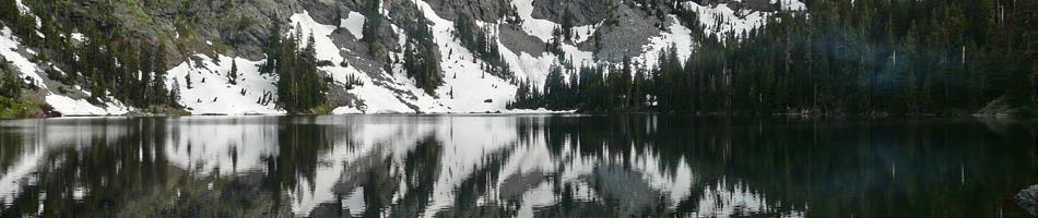
We were more than surprised at the stunning scenery encountered on this trip. East Boulder Lake is contained in an open bowl, surrounded by a red rock cirque. The vegetation is high desert, not typical for this country but probably due to cattle grazing who have eaten sage seed in the Scott Valley. Sage and white pine abound.
We were alone at the lake in the best campsite, which is about midway down the trail on the east side of the lake, before the inlet stream. There was enough room for our four tents. There is another campsite on the southeast end of the lake, but it did not look very level. Before our stay was done, there were two sets of campers camping very close (too close) to the shore on opposite ends of the lake. When we first came in, there was lots of wind, which was blowing straight into the camp on the north shore.
After setting up camp, we dayhiked the trail to Middle Boulder Lake. The trail starts from the east shore, back towards the lake outlet from the campsite. There you need to bushwhack through a meadow a hundred feet or so to get to where you see a trail that climbs to a low ridge out of the lake bowl.
The trail to Middle Boulder was pleasant, and the lake itself was nice to look at from above. The trail peters out after passing the lake at a boggy area filled with wildflowers. Hopping over some rocks, we found a sign pointing to the PCT. The books say that getting to the PCT from Middle Boulder is unmarked and requires trail finding skills. It proved to be much easier than we were led to believe, which we learned the next day.
On our second day, we walked from E Boulder to the PCT. From the lake, there is no trail – one needs to do an easy, although upward cross country walk for a short distance. Cross the inlet creek and continue in an easterly direction, up towards three absolutely stunning ponds. The trail becomes very clear at the ponds. There is at least one campsite by the ponds, which looked very nice, though smaller than ours.
The trail from the ponds to the pass ascends 280 feet in a short distance, but without a backpack, it is definitely not very difficult. It felt like we were at the pass in no time.
The scenery from the pass and the PCT was jaw-dropping beautiful. We walked southwest on the PCT through lots of red rock boulders, with views of Shasta and Mt Eddy, sawtooth ridges and eventually the alps of the Trinity Alps Wilderness. The path offered a constant stream of wildflower gardens. We stopped often for pictures and flower ID-ing.
After 2.2 miles, we came to the turn-off for Middle Boulder, with a sign that couldn’t be missed. Cory and Greg decided to complete the loop, by taking this turn and found the trail well-traveled and easy. They followed the trail down into the valley where there is a small rock cairn and a wooden sign tacked to the back (east) side of a tree indicating the PCT, from which they had just descended, and East Boulder Lake. This was the sign we had seen on our first afternoon, just beyond the boggy stream where we had turned around. They then continued on the trail, past Middle Boulder Lake, to E Boulder Lake.
Denise, Kathy, and Mary decided to return on the PCT. When they got to the junction with the trail to E Boulder (going west) and Marshy Lake (going east), Denise and Kathy took the 1.5 mile trail to Marshy Lake, while Mary continued back to E Boulder Lake. Denise and Kathy returned later to E Boulder, not having found Marshy Lake.
Little Bald Hills: Jul 6-7, 2015
Hikers: Mary “Fireweed” K., Denise “Trailhopper” F., Elisabeth “Gazelle” Z.
Trip Report and Photos from Mary K. [.pdf; 1.1Mb]
Union Lake: Jun 29- Jul 2
Hikers: Maria, Steve, Nick, Sooney
This trip’s original destination had been ever-popular Caribou Lake, but given triple-digit temps in the valley, our intrepid, heat-tolerant band opted instead to explore a brand-new destination with shorter distance, more day hike options, and especially more drinking/cooling water along the way.
Day 1. Union Creek TH (@ 4600′, off Coffee Creek Rd) to Union Lake (@ 6200′): 6.2 mi. Steady uphill (not steep), mostly in trees, with several cool creek crossings. We decided that Union Lake should be renamed “Union Pond” due to its shrinking diameter and depth. There were two campsites, suitable for small parties (2-3 tents); we obtained water from a tiny creek closer to our campsite, though lake water lake would’ve been ok. Although other lakes (see days 2 & 3) were more stunning and better for swimming, Union L. was a convenient, pleasant site, nestled in a cirque & meadows, with many birds, an occasional deer, and we think an unseen bear. It was also close to several day hikes, so we decided to stay there 3 nights rather than move camp. Evening game: Farkle.
Some general notes: We did find lower temps at our higher elevations (6000+’) though it was hotter on later days, and on open rock. For future trips, we’d suggest a campsite closer to Union Creek & Foster Lake trail (see map in photos; trip then might be renamed “Union Creek”), even more centrally located for the Foster & Landers Lake dayhikes (i.e., eliminating each day’s 0:45 RT ‘commute’ from Union L.); day hike to Dorleska Mine would backtrack along main trail in either case. Surprising number and variety of wildflowers & birds [see Nick’s report]. We rehydrated at several small creeks along each hike before steep sections. Trail signage was generally good, though there were numerous (possibly confusing) intersections near Union Lake, and several grassy meadow passages were almost imperceptible due to infrequent traffic.
Day 2. Given that the already hot temps were forecast to increase each day, we tackled the most ambitious (steepest & sunniest) hike first, from Union Lake to Foster Lake (@ 7250′): 6.0 mi RT. Foster was a spectacular lake, and we all partook of its cool, deep, clear waters. Two small campsites. After lunch, we hiked another ~0.5 mi. up the trail to peer down at Lion and Conway Lakes. Note: continuing ~8 mi., one could reach Boulder Lake [reports: 2015, 2014].
Day 3. A longer, but less steep day hike to Landers Lake (@ 7060′): 8.2 mi. RT; we grumbled about a 200′ ‘dip’ in trail. Landers Lake, too, was spectacular, and swimmable; two campsites. Steve (aka ‘Mountain Goat’) scrambled up Red Rock Mountain (@ 7853′) for a 360-view; there were no discernable cairns or trail, but it was straightforward to ascend boulder & scree slopes (~1:30 RT). Note: continuing ~7 mi., from a trail junction at Union Creek Meadow, one could reach Lilypad Pass [2014 Thumb Rock/Lilypad Lake day hike]. Evening game: Cribbage.
Day 4. It took about 3-1/2 hrs to return to car, including several stops to douse clothing in creeks, and to chat with the only other human of the 4 days (a local day hiker w/ her dogs) — so, this hike ranks 10+ on Tysen’s Solitude scale. Lunch at Bob’s Ranch House in Etna, with an extensive menu of food — and beer, including some from Etna Brewing.
Nick’s write-up has more details and perspectives, including partial lists of the many wildflowers we saw, and Sooney’s bird sightings.
Photo credits: Nick, Maria, Steve

