Lassen Volcanic National Park (Warner Valley area); 5-7 July, 2021
Eight people – Tony Davis (co-ordinator), Greg Conaway, Ana Rivero, Cory Ross, Barb Settles, Laura Smith, Len Wyatt, and Elisabeth Zinser – camped and hiked in the Warner Valley area of Lassen Volcanic National Park from 5 to 7 July, 2021.

Day 1 (Monday 5 July 2021)
Because we were unsure of the demand for campsites in the Warner Valley Campground (see below for more on this), both Cory and Greg and Ana and Len set out early. The others met in Ashland and left a bit after 8 am for the 4.5-hour drive to the Warner Valley. We were slightly concerned about smoke from the Lava Fire, near Weed, drifting into Lassen, but once east of Mt. Shasta no smoke was evident, and the weather, though hot, was beautiful throughout our trip.
The drive to Warner Valley is straightforward. The last section, from Chester, CA to the park, is partly on narrow roads, and the last section is dirt and gravel with some washboarding. We secured campsites without difficulty thanks to the vanguard arriving promptly. The campsites are a bit dusty, with some shade, restrooms with pit toilets that were reasonably clean, a spigot with potable water (“best in the park” according to an employee who stopped by to test it), and massive concrete picnic tables. Hot Springs Creek runs a few hundred feet away down the slope; it isn’t geothermally heated despite the name, but does offer some small waterfalls and pools to soak your feet in. Overall, it’s a decent campground.
After lunch we headed south on the PCT, alongside the creek for a half mile or so, to a junction with a strikingly massive cedar, and then climbed a bit to Boiling Springs Lake, which is geothermally heated, sulfurous, and bubbling. There’s a short loop around it, and we continued on a mostly shady trail paralleling the PCT towards Terminal Geyser. This trail isn’t too steep until you get to the short spur to Terminal Geyser, which drops quickly to another small creek at a spot where it runs over a fumarole. This is Terminal Geyser, not really a geyser, but a continuous belching of steam and gas that you can get fairly close to. We returned to camp via the PCT, passing through a large meadow filled with corn lilies, for a total hike of about 6.5 miles, enjoyed dinner, and went to bed fairly early.
Day 2 (Tuesday 6 July 2021)
After breakfast, we headed up the PCT in the opposite direction as it climbs the ridge north of the campground. Some of this south-facing slope is a bit more exposed than the forested areas around the campground, so we were glad to get going before it got too hot. Elisabeth started a bit later than the rest of us and walked this portion of the PCT and further towards Corral Meadow, then enjoyed a shady spot by a small creek. The rest of us turned left after about 1.5 miles onto the trail for Bench Lake and Kings Creek Falls. This area is a mix of forest and more open areas. Throughout our trip, we noted the unusual diversity of conifers – perhaps an indication of a healthy ecosystem. This stretch of trail is mostly a long slow climb, leading to an area of gray volcanic rock. We then took the right fork at the junction to descend to Bench Lake, which was completely dry. Less than a mile beyond that, the trail reaches Kings Creek near the falls, which were not dry. There are a couple of viewing areas at the top, and you can clamber down to the base if you’re careful, to enjoy the cool moist spot with some bright red penstemons clinging to the rocks.
We stopped for a lunch break along the creek above the falls. The trail along the creek (the busiest that we encountered in the park, though not truly crowded) heads westward and becomes a steep, one-way, series of steps in the rock, along a beautiful stretch of cascades. This half-mile section was hot and exposed, but very worthwhile. At the top are meadows and bit more shade. There we crossed Kings Creek again and began the loop back to the junction near Bench Lake, and on back down to camp the way we came. The total distance was about 9 miles, with 1500’-1800’ elevation gain, so this hike was a bit more taxing than the others.
After a rest and some relaxing down at the creek, we walked a bit under a mile on the southbound PCT, where we spotted a family of grouse, and then on a spur over to Drakesbad Guest Ranch for dinner. This is the only lodge in the park, and it’s a curious mix of old-time charm and somewhat inefficient, confused service. The idyllic setting is compromised by a loud electrical generator (solar power would seem to make a lot of sense here). Non-guests can eat there with advance reservations; ours were at 6 pm, which was a good thing because later it became crowded and they ran out of their one meat selection (NY strip steak). The vegetables were well prepared. The cold drinks were welcome. The patio was shady. The prices were moderate considering the remote location, but be aware that they serve mostly lodge guests whose meals are included in the price of their stay; it it is not prix fixe, even though the menu can give that impression, and every item costs extra.
On the way back, those of us who took the trail, rather than the more direct road, spotted a large bear loudly scratching logs for grubs. Back in camp, a second bear was engaged in the same activity, and came very close to some of our tents. There are bear boxes at the campground but we kept our food in our vehicles, and nothing happened to it. It was a bit startling to have a bear so close, though.
Day 3 (Wednesday 7 July 2021)
We again set out around 8 am, this time heading south on the PCT to the Drakesbad turnoff and then on a trail to Devil’s Kitchen, another geothermal area with boiling mud and brightly colored sulfur and other minerals. We had this place mostly to ourselves. We returned via a detour that involved a creek crossing – a bit surprising considering that most of the trails in the park are maintained to a high standard and would have bridges, but this trail looks less frequently used. We were back at our campground shortly before noon, after about 5.5 miles of fairly level hiking. After lunch around a picnic table and wishing Ana a happy birthday, we set off for home or other destinations.
Things to keep in mind
This trip went very smoothly. We learned a couple of things worth noting, though.
Campsite availability can be, to put it politely, “dynamic”. The park’s website indicated that all the sites at the Warner Valley Campground were first-come/first-served (no reservations possible). Then, about a week before our trip, suddenly 8 of the 17 sites were reservable, and had already been reserved! People in our group noted that similar things have happened elsewhere, too. We had a couple of backup plans if all the campsites had been taken, but they would definitely have complicated our trip and lessened our enjoyment. Luckily, because it was midweek and some of us arrived early, we could stick with our original plans. But the lesson is that it’s worthwhile to check frequently about campsites (and maybe other facilities and services as well), because the rules can change.
The second point is that bears seem to be ubiquitous in Lassen, and probably elsewhere. Take their presence seriously and behave accordingly, stowing food and other items securely.
Lastly, Drakesbad Guest Ranch is a quirky sort of place, but we enjoyed our dinner there, and it’s good to know what it offers, and what it doesn’t.
For those who enjoy a taste of the wilderness experience that backpacking provides, but who prefer camping in an organized campground and going on day hikes, this is a pleasant and scenic option, and the geothermal features are striking.

One of our campsites at the Warner Valley Campground 
small, shady waterfalls on Hot Springs Creek, below our campsites 
setting out towards Boiling Springs Lake on the PCT southbound 
setting out towards Boiling Springs Lake on the PCT southbound 
a large cedar on the PCT, en route to Boilings Springs Lake (and Terminal Geyser) 
Boiling Springs Lake 
Boiling Springs Lake; some trees manage to survive close to the sulfurous water 
Terminal Geyser 
you can get pretty close to Terminal Geyser 
Laura and Elisabeth at Terminal Geyser 
meadow full of corn lilies, on the way back from Terminal Geyser 
balsamroot flowers on the PCT, heading back from Terminal Geyser 
hang onto your hat in the Lassen gales! 🙂 
snow plant on the PCT, heading from our campsite to Kings Creek 
forests contrast with volcanic boulders on the trail from Bench Lake to Kings Creek 
volcanic rubble above the trail from Bench Lake to Kings Creek 
looming columns above the trail from Bench Lake to Kings Creek 
Kings Creek Falls 
the short, steep trail to the base of Kings Creek Falls 
rainbow at the base of Kings Creek Falls 
penstemons at the base of Kings Creek Falls 
more waterfalls going up Kings Creek 
cascades of Kings Creek 
more cascades of Kings Creek, which extend for hundreds of yards 
the trail along the Kings Creek cascades is steep but well constructed 
sugar pine cones, large enough to hurt if they hit your head on their way down 
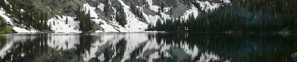
Along the PCT north of our campsites 
grouse on the trail from our campsites to Drakesbad Guest Ranch 
Drakesbad Guest Ranch, where we had dinner one night 
sign at Drakesbad Guest Ranch 
dining on the patio at Drakesbad Guest Ranch 
a large bear on the trail back from Drakesbad Guest Ranch 
the bear was rooting around in old logs, making quite a bit of noise 
fumarole at Devil’s Kitchen 
Devil’s Kitchen 
colorful mineral deposits and smelly water at Devil’s Kitchen 
sulfur is all over Devil’s Kitchen 
view of the Painted Dunes, from the Cinder Cone in the northeastern part of Lassen Volcanic National Park
Lassen Volcanic NP; Jun 28-Jul 1, 2020
Hikers: Jay A, Tony D, Denise F, Esther G, Karen G, Lee H, Kim M, Barb S, Dick T, Linda T
Trip Report (.pdf)
Lassen Volcanic National Park—the southernmost Cascade Range volcano by Landscapes Revealed (Karen G.)

