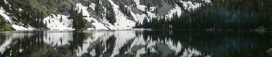
Steens Mountain: 1-6 September
Hikers: Maria G., Mary K., Tony D., Barb S., Sherry W., Charisse S.
[photos coming soon!]
Sep 1, Fri. Mary and Charisse left Ashland at 7am. Maria, Barb and Sherry left at 8:30, stopping at Burns to pick up Tony who had been in the John Day area for a couple of days. It rained intermittently on the drive but stopped before we arrived at South Steens Campground (SSC, $8 per night per site with Senior National Park Pass) allowing us to pitch tents and eat without getting wet. SSC is at the end of a well maintained 20-mile gravel road; it has 34 sites and although it was Labor Day weekend, only about half of the sites were occupied. It’s shady, with toilets and a pump providing potable water at one end of the campground. That night there was a thunder and lightning storm in the area and it poured on us.
Sep 2, Sat. We had expected rain on Friday when we drove to SSC but the forecast before we left was for clear weather after that, so the plan was to backpack into Big Indian Gorge on Sat. Well, it was still raining when we awoke, and instead we did a day hike of a bit over 9 miles in Little Blitzen Gorge. This was nice for Mary and Barb who had been to Steens two previous times but had not gone very far into Little Blitzen. The trail is in good shape; there’s one creek crossing early on, for which water shoes might be handy. It rises gradually and isn’t difficult to follow. The rain stopped after a few hours and we hiked in 4.5 miles, a bit past a campsite that could accommodate 2 tents or squeeze in 3 small ones. That night back in camp there was another a thunder and lightning storm and it poured on us.
Sep 3, Sun. Rain continued the next morning, but we were all tired of spending time in our tents, so off we went in our rain gear to Riddle Brothers Ranch, a historic site maintained by BLM. Because people had been removing artifacts, there is now a gate on the road and volunteer caretakers, who welcomed us and explained the history of the area. It’s possible to drive to it on the gravel road that we walked, except on Mondays and Tuesdays when the gate is closed. In all, we ended up walking about 9 miles this day. We also learned from the caretaker that the Desert Meadows Trail we had considered hiking was a “hypothetical” trail, pretty much impassable as it hasn’t been maintained for a long time. Weather cleared and we hiked 1.5 miles on the Levi Brinkley Trail from the historic ranch site to the confluence of the Little Blitzen and Donner und Blitzen rivers. The name Donner und Blitzen is apt; it’s not after Santa’s reindeer, but thunder and lightning. But there wasn’t much rain Sun. night, yay!
Sep 4, Mon. (Labor Day). If we were going to backpack in Big Indian Gorge as planned, this was our last chance because we had reservations at Alvord Desert campground for Tuesday night ($25-30 per person for campsite including use of hot springs). It was cloudy but the forecast was for improving weather. What to do? Considerations included possible unforecasted rain (reports had been wrong all along); options if the one campsite were occupied (we’d seen backpackers in Little Blitzen Gorge); would there be time to hike Pike Canyon on Tuesday after backpacking out and driving to Alvord; tiredness. After much discussion, we all agreed that Mary, Barb (both of whom had backpacked twice in Big Indian Gorge and Charisse (who was excited to try out her new gear) would backpack into Big Indian Gorge and Maria, Tony and Sherry would go with them for 5 miles and day hike out. This trail too is well maintained and ascends gradually; it has three creek crossings in the first couple of miles, for which water shoes are advisable. As it turns out, there’s a campsite a bit less than 5 miles in, below a distinctive rock standing in a grassy area; a short, indistinct trail slants down to a grassy campsite by the creek. After having lunch together and setting up camp, the backpackers reached several waterfalls cascading down the gorge walls. The campsite easily accommodated their 3 tents, was shady; however, with the clear skies, it was a cold, damp night.
Sep 5, Tue. The day hikers drove the Steens Mountain Loop Road up to its closure due to rockfall and walked to overlooks of both Little Blitzen and Big Indian Gorges. The views from here are impressive. About a mile beyond the gate, three large boulders have been placed in the road, suggesting that the closure of the continuation of this road to the top of the ridge and the Wildhorse Lake trailhead may not be temporary. It would be worthwhile to check the status of this road before planning to drive up there (access to the Wildhorse Lake trailhead would still be possible via the North Steens loop road, even if this road remains closed, but the drive is quite a bit longer). Around noon, the day hikers drove about 70 miles over to Alvord to camp at Pike Creek. They had plenty of time to hike 2 miles up the Pike Creek Trail, which offers some spectacular views and rock formations. It’s drier than the trails we hiked on the west side of Steens, and a bit steeper (average about 500’ elevation gain per mile, with some up and down). The backpackers arrived at Alvord around 4pm, after a short side trip to Fields Station to enjoy their famous milkshakes. Charisse’s husband Walter arrived at 6pm, and we all drove 3 miles to soak in the hot springs until after dark. The campsite is pleasant, but does not have toilets or a water tap (the creek is right there, though); the charge of $25-$30 per person seems a bit on the high side, but it’s probably the best spot in the area. The night was clear and warm.
Sep 6, Wed. We drove home. Maria’s car started home at 7:30am and stopped at the BLM rest area between Lakeview and Bly for a picnic lunch and got home at 2:30pm. Mary and Tony headed back a bit before 9 am. They were looking forward to lunch at the Indian taco stand in Bly, but it was closed until 20 September. They returned to Ashland at about 5 pm.
Wildlife isn’t that abundant in this area. Bears don’t seem to be present, but we did see a fair amount of coyote scat (they seemed to be enjoying the several varieties of red berries that are in season). We saw some wild horses in the open areas near the road into South Steens Campground. A couple of eagles soared above us as we hiked the Pike Creek Trail. We encountered a praying mantis devouring a grasshopper and a tiny bright green frog in that area as well. Mud wasps were visible there, too, and rattlesnakes apparently inhabit the canyon. For eastern Oregon, Steens is surprisingly green, and late-season wildflowers – rabbitbrush, goldenrod, sunflowers, purple asters, and gentians – added color to our hikes.
Wild Rogue Loop: 22-26 May 2022
Mary Kwart backpacked solo on the Wild Rogue Loop.
I backpacked this a 27 mile loop by myself—no takers from the BIG group. I repeated the trip I did in June 2021. The hike starts near the Lower Rogue River, then goes up Mule Creek to Panther Ridge, then down toward Clay Hill Lodge, then on the Lower Rogue Trail back to Tucker Flat.
May 22-Day 1
I drove the three hours to Tucker Flat Campground, near Marial Lodge on the lower Rogue River. I used the route through Glendale about an hour’s drive north of Ashland off I-5 because it only has 10 miles of dirt road as opposed to the route through Grave’s Creek. The Campground was very quiet—no one else there. Great large flat site with a picnic table and campfire grate. No fee. No water, but I brought some containers in my truck. I had a pleasant evening—brought some firewood from home to have a campfire. The Tucker Flat is above Mule Creek (although it is too steep to get down to it) so you can hear the water rushing.
May 23-Day 2—around 8.5 miles
I packed up and got going around 9:30 up Mule Creek. My aim for this trip was to go as lightweight as possible—I went stoveless and pared down to 20 pounds, including 4 days of food and one liter of water. I left my truck at the trailhead parking. Lots of wild irises and other wildflowers. Temps were moderate. I got to the original planned campsite early, so decided to carry on to another campsite with water a couple mile up the trail near Hanging Rock. Lots of elevation gain this day, but was in the trees and shade for a large part of the day. Plenty of water running in Mule Creek at the top of the ridge. I quickly left behind poison oak as I got up to higher elevation. Trail is easy to follow. There were two refreshing fords of Mule Creek, but not deep. I would recommend using poles. Very cold water. My camp near Hanging Rock by a water source pool under a large tree was shady and it was surprisingly cool at night.
May 24—Day 3—around 7 miles
The day started with more uphill, which concluded the elevation gain for the entire trip—all level and downhill the rest of the way. Great views from Panther Ridge. I had gone to Hanging Rock last year, so didn’t repeat this off trail hike. Very steep downhill with lots of switchbacks toward Clay Hill Lodge. I camped at the Old Thomas Homestead where there was water.
As I was eating dinner I heard cracking behind me—I said to myself “Oh—must be a bear. Hah hah!” not taking it seriously. When I got up and looked around I saw the bear peering at me from 30 feet away. I yelled at it and it sauntered off. I went above the meadow far away from my camp to hang my food. When I turned around, the bear was walking across the meadow a couple hundred feet away from me. He was walking toward me and broke into a run. I have never been bluff charged, but I guess this was the first time. I walked toward the bear and waved my hands and spoke in a stern loud voice. It stopped in its tracks and moved off toward the side of the meadow. It visited me again around 8 at night in the camp and I yelled at it and it left again. It never returned the rest of the night. The question was: did it get my food? I had heard a cracking sound in that direction like a large branch had fallen.
May 25—Day 4—11.5 miles
My food hang was successful—my food was still there in the tree. I think the habituated bears in the Rogue River area are used to people abandoning their food when they appear—a much easier way to get food than having to crawl up a tree or snap a big branch. This explains the bear running toward me.
I quickly broke camp and resolved to eat breakfast at Clay Hill Lodge porch overlooking the river, away from the bear infested Old Thomas Homestead. On my way down the trail I saw the bear up ahead walking on the trail. He heard me and stopped but was unsure; I yelled at him and he rushed off the trail
I decided I didn’t want to experience more camp bear intrusions, which were sure to happen using the campsites along the lower Rogue (even though they have bear boxes and electric fences), so I walked back to my truck. The lower Rogue was spectacular as usual. I was vigilant to avoid touching the poison oak along the trail and I haven’t gotten any rash at all. I enjoyed watching the kayakers and other boaters.
I stayed in Tucker Flat Campground and enjoyed a peaceful night—no other campers in the campground again.
May 26—Day 5
I had a leisurely breakfast in Tucker camp and drove home. Last year I had several ticks, but none this year, probably because it was earlier and cooler.
Lessons Learned
I would carry a bear canister or Ursack next time. It was too much of a hassle to hang food, although it is a lot less weight to carry hanging gear over a canister or Ursack. Although having a canister still means the bears will come into your campsite, which is still pretty nerve wracking. I reported the encounters to the Rogue River National Forest. I think the bluff charge by the bear is a precursor to more aggressive behavior.
Another option for this trip is to stay the third night at Paradise Lodge next to the lower Rogue. I was thinking of staying there and called to make a reservation before I left Ashland. They did have room, but I got the message too late. No cell service anywhere except up on Panther Ridge. Also, Marial lodge said they can open the lodge if 6 people commit to stay. At the time I planned this trip they were not going to open until later. This would be an option for the first and last nights stay.
This is a classic southern Oregon route—river to ridge and back with the option to stay at lodges.


Car Camping and Day Hiking on the Coast and amidst Redwoods; 8-12 July 2021
When the Farewell Bend Camping and Hiking trip had to be canceled due to smoke in the area, the participants – Cory Ross, Greg Conaway, Jo Ann Haun, Elisabeth Zinser, Rosalie Rybka, and Linda and Richard Thomas – set out to find alternatives on the Oregon and northern California coast where the air quality remained good. What follows is an example of the resilience and determination of BIG members enthusiastically bound for outdoor adventures.
Cory and Greg headed into central Oregon coastal areas with their camping van. Spending their first night at Cape Perpetua Campground, they had dinner in Yachats before heading to the peak of Cape Perpetua and the Whispering Spruce Trail to watch a stunning sunset over the ocean. Next day, they tide-pooled below the Adobe Hotel in Yachats and then enjoyed a few hikes: Captain Cook and Thor’s Well, Devil’s Churn, Trail of the Restless Way, and the Giant Spruce Trail. The campsite is along a single road with tent sites set back nicely along the creek and RV sites closer to the road. There are pit toilets and running water in the sinks.
Next, they went to Tahkenitch Landing for 2 nights. Winds came up during the day, but quiet at night and morning. They paddled in their inflated kayaks and they hiked the Tahkenitch Creek Trail and the Tahkenitch Dunes trail as an out and back to the beach as far south as the sign prohibiting motorized vehicles to protect the snowy plover nesting sites. The campsite is on two levels, lakeside and shoreline (which is steep). The lake is only accessible from the boat launch to the north, close to the road. Highway noise was present at camp, but not on the lake fingers away from the road. Then Greg and Cory were off to the Jessie M Honeyman Memorial SP (with electrical hook up, showers, etc.). They hiked right from the campsite over to west shore of Lake Woahink. And they had a peaceful put-in spot to kayak at Lake Cleawox (keep right on entering the day use area and park at the northern parking lot).

They made a sweet discovery testing a narrow channel just left of the Girl Scout dock and discovered the 3-mile long, hidden water-lily edged finger of the lake with kingfishers among others. This was the most beautiful paddle they’d ever enjoyed!
Here are some highlights of their time on the Oregon coast:


Meanwhile, in the Redwoods at Jedediah Smith State Park, Richard, Linda and Rosalie set up their camp and welcomed an informative visit from a friend of Rosalie’s who has a long career in the Park Service. Mickey Kacherwski took them on an interpretive hike by sharing his knowledge of the ecology, the trees and other plants. When Jo Ann and Elisabeth arrived in the afternoon, they enjoyed a shorter hike on trails in the extensive campground to learn more from Mickey, joined by Richard and Rosalie.
The campsite was very spacious and right along the Smith River. It was a special treat to meander down to the riverbank to sit and visit and enjoy the wildlife along the river. Linda, Rosalie and Elisabeth crossed the river on a footbridge from the campground into the Stout Grove late in the day to revel in the majestic Redwoods on that heavily traveled 1.6-mile loop trail. Such a joy to see families with young children experiencing this magnificent natural world.
The next day, the BIG group of five ventured onto the Boy Scout Tree Trail to complete this rigorous 5.6-mile RT adventure. While the elevation gain is just a net 200 feet, hikers navigate constant roots on the surface of the trail connecting all these magnificent trees making up the forest community. Climbing up and down (between 250’ and 450’ twice), sometimes aided by human-engineered stairs. The undergrowth is lush, dominated by varieties of fern (deer and sword), tanoak and evergreen huckleberry. The trail passes through silent stands of ancient trees seemingly undisturbed for many centuries. The forest features the two largest conifer species in the world, the Coastal Redwood and the Douglas-fir (as much a Hemlock as a Fir). On top of all this, there’s an area along a side canyon with bigleaf and vine maple. About 2.4 miles in, a steep but short side trail leads to the enormous, double-trunked Boy Scout Tree (named by Sheriff Jack Breen who founded the local Boy Scout troupe many decades ago). Back on the main trail, the group found coast red elderberry and salmonberry growing along the Jordan Creek, and some bigleaf maple, vine maple, and cascara. The turn-around spot is down the hillside at shaded Fern Falls cascading over a rock outcropping. On the return trek, the BIG group of five found veteran BIG member Mary Kwart coming along the trail. She and they were stunned and delighted, and captured a group photo with her thanks to a group of young hikers nearby.
Each evening, the group enjoyed sharing time in camp—talking, reading, sitting beside the river, and sharing items of food brought for dinner time. Sometimes entertained by neighboring campers, such as a small friendly boy eager to share his family’s tradition of painting designs with wax-crayons on a fire-heated rock each evening. Sometimes aggravated by noisy youth having a party. All in all, it was an ideal car camping site. Bathrooms and showers quite modern and very clean and private, albeit up a long staircase necessitating late night flashlights. On August 12, the group delayed returning to the smoke in the Rogue Valley. Rosalie found a place to stay into the weekend in Gold Beach. Jo Ann led the remaining four to visit the wharf in Crescent City, where they clambered up the rocks at the end of the wharf, navigating a ‘forest’ of poison oak to take in the views out to sea and over the city’s crescent beach and town.
Here’s a gallery of their trip:


2. New River 


