Latest
BIG history: 2009-2024
Tysen Mueller
Shortly after I retired in December 2006, I set a goal of hiking a stretch of the Pacific Coast Trail (PCT). This trail runs 2,660 miles from the Mexican Border in California to the Canadian Border in Washington State. Each year, about 300 hikers attempt to hike the full stretch in a single year, requiring about three months or more. A smaller number try to hike it both ways in a single year.
Originally, I wanted to hike from Mt. Ashland, near my home in Ashland, to the vicinity of Mt. Shasta. When I finally examined a trail map of the PCT, I realized that this stretch of trail is more than 200 miles long. As a result, I set a more modest goal of a week-long, 49-mile hike of the PCT through the Marble Mountain Wilderness.
I enlisted my old friend Jim Ross, who lived in the Bay area but who had never gone backpacking. We decided to take a 4-day, 20-mile, backpacking trip into the Sierras east of the Sonara Pass in the Walker Basin. This light-to-moderate trip allowed us to check out our gear as well as our fitness. I had not backpacked for ten years. From this trip, I learned the value of keeping my electrolytes balanced to avoid heat stroke. I also learned the value of trekking poles so that I could use all four limbs when climbing or descending on a trail.
Jim joined me on our PCT trip in August 2007, after only two prior backpacking trips. For me, it was the realization of a goal that I set for myself in December. It was also my longest trip in more than 40 years. On that trip, Bob Campbell, my backpacking mentor, and I hiked through the Kings Canyon and Sequoia National Park in nine days.
Jim and I hiked the PCT for more than 50 miles between Etna Road and Grider Creek Campground in six days without difficulty. During the days, we had sunny weather with clear skies and temperatures into the 80’s at an average elevation of 6,500 ft. At night, we had a full moon and temperatures in the 50’s. My gear weighed more than 45 lb at the start while Jim’s weighed around 28 lb.
Rather than continuing to count on Jim to join me for backpacking trips in Northern California or Southern Oregon, I decided to find backpackers in the Ashland area. So I prepared a course on backpacking to be taught at Southern Oregon Learning in Retirement (SOLIR), currently known as OLLI. This is an adult education program in Ashland. The course was taught January 2009, under the title: Backpacking in your 60’s. While this first course consisted of only three lectures, I attracted a group of like-minded individuals.
From a small group of people that had taken my course, I founded the Backpack Interest Group (BIG) in February 2009. Our mission statement is:
BIG provides opportunities for backpackers in their 60’s and 70’s to backpack in Northern California and Oregon with like-minded individuals.
I believe some of the founding members were: Alan Pendleton, Elizabeth Aitken, Terry and Chiyemi Doyle, Mary Ehlers and Rhoda Ralston.
I taught this course again during the Spring 2009 Term and continued teaching versions of this course for the following four years. From these courses, I continued to draw members into BIG.
Our membership growth has been:
- 2009 – 10
- 2010 – 16
- 2011 – 16
- 2012 – 26
- 2013 – 22
- 2015 – 42
- 2017 – 43
- 2018 – 43
To provide an online presence, in 2009 Elizabeth Aitken created the BIG website, which you are now viewing (https://ltbackpackers.wordpress.com)
We both had taken a SOLIR class on creating websites and blogs, taught by Terry Doyle. At the end of 2009, Terry took over the blog. In 2011, Steve Weyer took charge and under his stewardship, it was greatly enhanced. Currently, Tony Davis is maintaining it.
The backpack trips are led by experienced members. Trips are planned at the beginning of the year at our periodic (monthly) potlucks. These popular potlucks also provide an opportunity to network as well as to show slides from recent trips.


I led the Group for two years (2009-2011). Then, I turned over the leadership to Steve Weyer and Maria Geigel who led it for four years (2011-2015). They in turn, handed over the leadership to Mary Ehlers for two years (2015-2017). I stepped back in again as the leader for one year (2017-2018). Elisabeth Zinser then led the group for two years (2018-2020). She was followed by Linda and Dick Thomas (2020-2022). Currently, Tony Davis has the led the group since 2022.

Based on a member survey in 2017, 91% are experienced backpackers, although 27% have not backpacked in the last five years. Most (68%) prefer trips that are moderate in difficulty while 23% prefer easy trips. Also, most (77%) prefer shorter (3-day) trips.
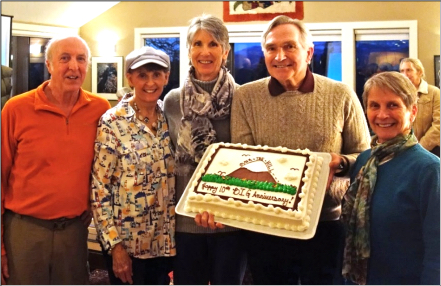
(Steve, Elisabeth, Mary, Tysen & Maria)

For the first ten years, Tysen borrowed a digital projector from his Rotary Club for presentations to be made at the BIG potlucks. Tysen argued that we ought to charge a nominal membership fee, with the funds to be used for purchasing our own projector. These discussions didn’t get much traction. Instead, Elisabeth led a drive prior to the BIG 10th Anniversary that collected sufficient funds to purchase our current BIG projector. Tysen donated his projection screen, providing the only assets that BIG currently owns.
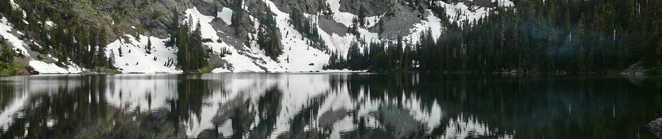
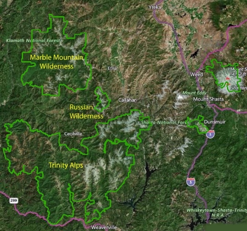
For our backpacking trips, our initial focus was on the wilderness areas in northern California. These consist of the Marble Mountain Wilderness, the Russian Wilderness and the Trinity Alps. as shown on this map.
I had seen a lot of beautiful lakes in the Marble Wilderness from the PCT trail that followed the ridgelines. As a result, I promised myself that I would hike into these lakes when I had a group of backpackers to join me. Here is one of our first backpack trips into the Marble Mountain Wilderness.

in the Marble Mountain Wilderness, July, 2009
I eventually hiked into at least four of these lakes as in the next map. Here, a stretch of the PCT that I hiked is shown in red. The hikes in yellow show the routes that we took to Sky High Lakes, Little Elk Lake, Cliff Lake and Maneaten Lake.
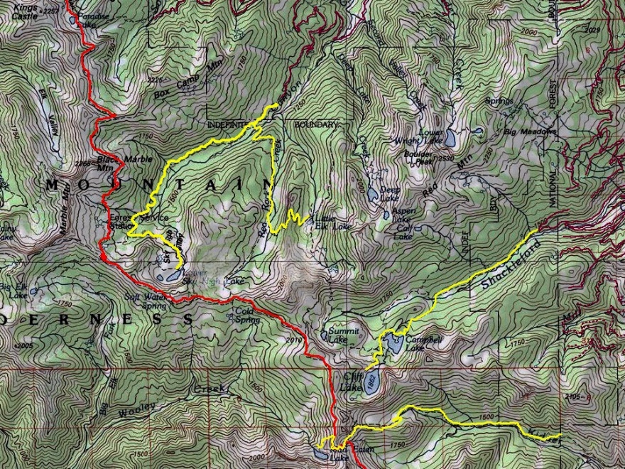
(red: PCT, yellow: Sky High Lakes, Cliff Lake, Cliff Lake & Maneaten Lake)
This year, 2024, BIG is celebrating its fifteenth anniversary. Over these years, I have led a variety of backpack trips in Northern California and Oregon. Typically, these trips were moderate 3-day trips. However, I have also led a few 4-, 5- and 7-day trips:
- 2009: Sky Lakes Wilderness, 5 days
- 2010 & 2011: Trinity Alps: Caribou Lake, 4 days
- 2012: Trinity Alps: Emerald Lake, 5 days
- 2016: Three Sisters Wilderness: ‘Reverse Traverse’, 7 days
- 2019: Mt Jefferson Wilderness: 5 days
Mount Shasta area: 10-14 September
Participants: Elisabeth Zinser (leader), Gabriele Bennett, Barb Settles, Nancy Skinner
Camp: Siskiyou Lake “Resort” Campground
Hiking: Siskiyou Lake, McCloud Falls, Castle and Heart Lakes
[photos coming soon]
On the Camp: For months we had been booked for a campsite at Jedediah Smith State Park, aiming for trails in the Redwoods and along the coast. Northern California fires brought frequent smoke into that region and Hwy.199 was closed for an extended period. I cancelled that reservation and booked a campsite at Lake Siskiyou when air quality was following a much favorable air quality pattern going into September. Having participated in a BIG adventure there under Tysen’s leadership a ½ dozen years ago. The ‘resort’ offers cabins (most very basic), an area for crowds of RVs, and many clusters of campgrounds.
The location was wonderful for the hiking opportunities and air quality, but less optimal for the condition of the Lake Siskiyou campground. While our campsite was ample for four tents, many sites were in disrepair (huge potholes even in our campsite drive) and former campers had left trash (especially beer and pop cans) strewn around in campsites and bushes. We disposed of many. It was obvious that the “resort” made no effort to clean campsites between campers. The restroom was cleaned daily, but needed maintenance. Access to showers was nearly ½ mile distant from our site. The only staff we saw was the occasional security guard cruising around a time or two each day. There were a few campsites in use nearby on our first day or two, but no one in sight by the time we departed. Apparently, very little use after Labor Day weekend.
In short, the Lake Siskiyou Camp ‘Resort’ charged higher rates than the conditions and amenities provided: $40/night base senior rate, added $20 for the second car, added $5/night for each of two additional campers. Perhaps pricing and conditions account for low usage, although the website had shown many “unavailable” sites. This is a private enterprise. It made me appreciate the customary conditions and pricing schedules of our state and national campgrounds, supported in part by our tax dollars and managed by competent state and federal employees.
On Hikes: We hiked each of our 3 full days.
Days One and Five (9/10 and 9/14): Mostly driving, camp set up/take down, eating.
Day Two (9/11): Hiking the trail around Lake Siskiyou for an 8-mile RT journey from our campsite plus a swim for three, and a 6.4-mile out and back for me. We were at about 3,200’ in this area. Our ascents and descents were under 800’. Very enjoyable hiking with great views. Of course, we recognized this anniversary of our nation’s/world’s tragedy on “9/11” twenty-two years ago.
Day Three (9/12): After a leisurely breakfast together, we packed up to drive to nearby Castle Lake. Horrors: One car would not start, no matter what we tried. The initial assumption was a ‘break freeze’ due to a tire up against the side of the huge pothole on our drive. Gabriele came to the rescue and called AAA on her membership. The assumption was that the car would need to be towed back to Medford and Nancy would depart early with AAA. A nearby camper tried jumper cables to jumpstart the motor. No luck. So, we bolted into action to prepare the other car for 3 of us to remain and return together, while Nancy took down her tent and packed her car. We stuck together as good campmates do, spending time in camp playing Barb’s fun game (Farkle) and/or reading. By late afternoon, AAA arrived with a big flatbed ready for towing. Then a ‘miracle’ – the gentleman had a very powerful motor to jumpstart the car successfully. The battery had taken a siesta because the inside overhead lights were left on for two days, and possibly also having had car doors open too long while accessing supplies and food. WORD OF EXPERIENCED ADVICE: It can be easy to inadvertently bump the switch to hold the inside dome light on (versus the position that has it go on when a door is opened and off within 30 seconds after the door is closed). Avoid leaving doors and trunk/hatch open for long periods of time when parking for extended periods.
Given the scenario we had come to expect, we were thrilled that Nancy could stay and the car was fine. So, the tent went back up while contents in cars were rearranged. Our next step was to take a drive somewhere to further charge up the car battery.
Nancy insisted that we save the day by driving to a hike somewhere. Barb came up with the solution: A drive to hike on the McCloud River Trail to view the McCloud Falls (lower, middle, and upper). Note: The ‘landmark’ to locate this trail is the Fowler Campsite located south of Mt. Shasta on I-5 (before Dunsmuir), taking Exit 736 onto Hwy. 89 (toward McCloud, Burney Falls, Lassen National Park), traveling past the town of McCloud to a right turnoff for Fowler Camp. Large parking lot located at the TH at Lower Falls.
Once at the TH parking, we took off to follow Barb’s guide to hike along the McCloud River in the lovely hues of late afternoon. Right away is the Lower Falls—a relatively short drop in a beautiful view up the river. Next we came to the Middle Falls—the most expansive flow of water coming down into river pools, quite inviting for several youth who were jumping off rocks and frolicking in the river. A special highlight was seeing the bright flowering Indian Rhubarb (see picture). At this point, the trail continues up a grade with switchbacks to a view down over the Upper Falls. The hike was less than 4 miles RT with an elevation gain under 250’. It was a perfect way to salvage the day.
One last glitch for the day: The return drive was confusing due to unclear ‘diversions’ to access I-5 because of extensive highway repairs (or perhaps my inability to follow the “diversion’ signs). In short, we meandered across to the other side of the freeway onto a narrow dirt back road in the woods, and then down into the residential area and finally Mt. Shasta Resort and Lake Siskiyou. Thanks to iPhone navigation and map, we made it.
By the time we arrived at camp, it was a dark for a challenging but fun experience cooking and enjoying dinner while wearing our headlamps and having the ‘candle light’ ambiance of a sun-powered night light on the table.
Day Four (9/13): A hike (climb actually) from Castle Lake to Heart Lake RT. Castle Lake access road is about ½ mile from camp and climbs a zig-zag grade for 7 miles up to the parking and toilets at Castle Lake. We arrived early and beat the usual ‘crowds’ (though minimal after Labor Day). We were nearly the first on the trail up to Heart Lake.
The rocky trail climbs just 1.3 miles but with a 600’ elevation gain to Heart Lake (a small lake in the shape of a heart). The views and forest flora along this journey are magnificent. Our three fast hikers continued on the trail past Heart Lake in search of an extended climb to yet higher terrain. I climbed up a knoll through the bushes to a favorite access point above Heart Lake that overlooks Castle Lake and the most expansive views north, east, and south. Mt. Shasta and lower intervening mountains were crystal clear.
Anticipating that my fellow hikers would be hiking for a long while, I enjoyed a beautiful meditative hour atop that knoll gazing over the landscape and Castle Lake below. Before descending, I walked around at Heart Lake, seeing it full of more water this time of year than I’ve witnessed on earlier hikes here (after morning kayaking on Castle Lake).
It was fun to encounter other hikers and dogs by this time of day. Several did not know to climb the bushy knoll above Heart Lake, so were thrilled to make that diversion for the views. A highlight was conversing with two women from Brazil who come to this region often to hike and enjoy terrain much different than in their country. From them I discovered that my fellow hikers had already passed by, descending back to Castle Lake. The Brazilians had met up with them. Ouch! I was unaware that they had encountered a trail closure early on their ascent above Heart Lake. So, I returned down the rocky trail as quickly as possible. They were enjoying quiet time on the shore, but eager to try the trail around the other side of Castle Lake in search of a good swimming spot. That we did together over rocky and tree-rooted tangles amongst magnificent trees and beside the crystal-clear lake sporting reflections of the cliffs on the other side. I knew some lake access spots from kayaking to them in the past. We found them for a refreshing swim.
On Camp-time and Meals:
We were such a compatible bunch. Our time in camp was full of good conversations, shared dinners, quiet time reading, and playing Barb’s game of Farkle (actually Barb and Nancy played). We prepared our own breakfasts and lunches, but enjoyed a shared dinner scheme. Each of us took one of our four nights to cook on Nancy’ stove. We enjoyed a variety of vegetarian recipes. Clean up was a group effort, making light, speedy work of it.
In summary, this trip had a few challenges and yet turned into a wonderful shared experience full of special memories and deepening friendships.
Steens Mountain: 1-6 September
Hikers: Maria G., Mary K., Tony D., Barb S., Sherry W., Charisse S.
[photos coming soon!]
Sep 1, Fri. Mary and Charisse left Ashland at 7am. Maria, Barb and Sherry left at 8:30, stopping at Burns to pick up Tony who had been in the John Day area for a couple of days. It rained intermittently on the drive but stopped before we arrived at South Steens Campground (SSC, $8 per night per site with Senior National Park Pass) allowing us to pitch tents and eat without getting wet. SSC is at the end of a well maintained 20-mile gravel road; it has 34 sites and although it was Labor Day weekend, only about half of the sites were occupied. It’s shady, with toilets and a pump providing potable water at one end of the campground. That night there was a thunder and lightning storm in the area and it poured on us.
Sep 2, Sat. We had expected rain on Friday when we drove to SSC but the forecast before we left was for clear weather after that, so the plan was to backpack into Big Indian Gorge on Sat. Well, it was still raining when we awoke, and instead we did a day hike of a bit over 9 miles in Little Blitzen Gorge. This was nice for Mary and Barb who had been to Steens two previous times but had not gone very far into Little Blitzen. The trail is in good shape; there’s one creek crossing early on, for which water shoes might be handy. It rises gradually and isn’t difficult to follow. The rain stopped after a few hours and we hiked in 4.5 miles, a bit past a campsite that could accommodate 2 tents or squeeze in 3 small ones. That night back in camp there was another a thunder and lightning storm and it poured on us.
Sep 3, Sun. Rain continued the next morning, but we were all tired of spending time in our tents, so off we went in our rain gear to Riddle Brothers Ranch, a historic site maintained by BLM. Because people had been removing artifacts, there is now a gate on the road and volunteer caretakers, who welcomed us and explained the history of the area. It’s possible to drive to it on the gravel road that we walked, except on Mondays and Tuesdays when the gate is closed. In all, we ended up walking about 9 miles this day. We also learned from the caretaker that the Desert Meadows Trail we had considered hiking was a “hypothetical” trail, pretty much impassable as it hasn’t been maintained for a long time. Weather cleared and we hiked 1.5 miles on the Levi Brinkley Trail from the historic ranch site to the confluence of the Little Blitzen and Donner und Blitzen rivers. The name Donner und Blitzen is apt; it’s not after Santa’s reindeer, but thunder and lightning. But there wasn’t much rain Sun. night, yay!
Sep 4, Mon. (Labor Day). If we were going to backpack in Big Indian Gorge as planned, this was our last chance because we had reservations at Alvord Desert campground for Tuesday night ($25-30 per person for campsite including use of hot springs). It was cloudy but the forecast was for improving weather. What to do? Considerations included possible unforecasted rain (reports had been wrong all along); options if the one campsite were occupied (we’d seen backpackers in Little Blitzen Gorge); would there be time to hike Pike Canyon on Tuesday after backpacking out and driving to Alvord; tiredness. After much discussion, we all agreed that Mary, Barb (both of whom had backpacked twice in Big Indian Gorge and Charisse (who was excited to try out her new gear) would backpack into Big Indian Gorge and Maria, Tony and Sherry would go with them for 5 miles and day hike out. This trail too is well maintained and ascends gradually; it has three creek crossings in the first couple of miles, for which water shoes are advisable. As it turns out, there’s a campsite a bit less than 5 miles in, below a distinctive rock standing in a grassy area; a short, indistinct trail slants down to a grassy campsite by the creek. After having lunch together and setting up camp, the backpackers reached several waterfalls cascading down the gorge walls. The campsite easily accommodated their 3 tents, was shady; however, with the clear skies, it was a cold, damp night.
Sep 5, Tue. The day hikers drove the Steens Mountain Loop Road up to its closure due to rockfall and walked to overlooks of both Little Blitzen and Big Indian Gorges. The views from here are impressive. About a mile beyond the gate, three large boulders have been placed in the road, suggesting that the closure of the continuation of this road to the top of the ridge and the Wildhorse Lake trailhead may not be temporary. It would be worthwhile to check the status of this road before planning to drive up there (access to the Wildhorse Lake trailhead would still be possible via the North Steens loop road, even if this road remains closed, but the drive is quite a bit longer). Around noon, the day hikers drove about 70 miles over to Alvord to camp at Pike Creek. They had plenty of time to hike 2 miles up the Pike Creek Trail, which offers some spectacular views and rock formations. It’s drier than the trails we hiked on the west side of Steens, and a bit steeper (average about 500’ elevation gain per mile, with some up and down). The backpackers arrived at Alvord around 4pm, after a short side trip to Fields Station to enjoy their famous milkshakes. Charisse’s husband Walter arrived at 6pm, and we all drove 3 miles to soak in the hot springs until after dark. The campsite is pleasant, but does not have toilets or a water tap (the creek is right there, though); the charge of $25-$30 per person seems a bit on the high side, but it’s probably the best spot in the area. The night was clear and warm.
Sep 6, Wed. We drove home. Maria’s car started home at 7:30am and stopped at the BLM rest area between Lakeview and Bly for a picnic lunch and got home at 2:30pm. Mary and Tony headed back a bit before 9 am. They were looking forward to lunch at the Indian taco stand in Bly, but it was closed until 20 September. They returned to Ashland at about 5 pm.
Wildlife isn’t that abundant in this area. Bears don’t seem to be present, but we did see a fair amount of coyote scat (they seemed to be enjoying the several varieties of red berries that are in season). We saw some wild horses in the open areas near the road into South Steens Campground. A couple of eagles soared above us as we hiked the Pike Creek Trail. We encountered a praying mantis devouring a grasshopper and a tiny bright green frog in that area as well. Mud wasps were visible there, too, and rattlesnakes apparently inhabit the canyon. For eastern Oregon, Steens is surprisingly green, and late-season wildflowers – rabbitbrush, goldenrod, sunflowers, purple asters, and gentians – added color to our hikes.

